Featured articles

Monday 27 October 2014

Manakau Uwerau Traverse

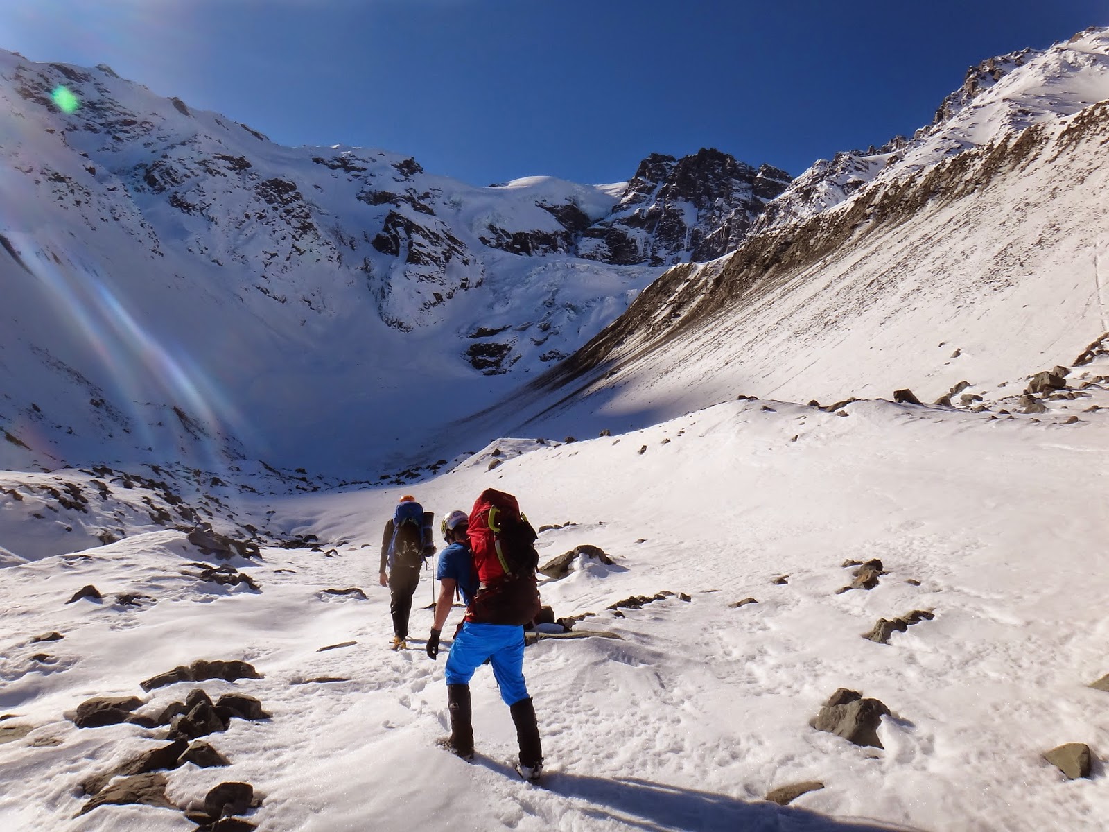
Dragging ourselves up a steep tussock slope, the scrub covered in icy dew, with nothing to be seen but mist clinging to the endless ridge above us… this was a most depressing start to our sea to summit attempt of Manakau, towering 2608 metres above the Kaikoura coastline.

Icy tussock climbing on the first attempt in June 2014.
Photo: Michael Eatson

Barratts Bivvy
Photo: Michael Eatson

The previous night we had slogged up the bouldery Hapuku stream bed, seriously underestimating the rugged approach for a Friday night walk-in, reaching Barrats Biv drained and strung out at 2am. But climbing higher on the Surveyor Spur ridge, our fortunes changed. Morning sun broke through the fog, suddenly revealing our Himalayan giants towering high above us against a blue-bird sky. The mountains of our dreams. Combined with the snow conditions of our dreams; solid cramponing on firm early winter snow felt effortless and we relished each kick of the boots and each swing of the axe.

Spectacular views over the Kaikoura coastline
Photo: Michael Eatson
But a climbing party is only as strong as its weakest link. Tom was new to mountaineering and was not equipped with the stiff boots required to climb such steep icy snow. His flexible walking boots wrenched with the front points struggling to find purchase. He looked insecure on the slope with each step. With Manakau looming above in the perfect windless blue skies, the summit call was strong, but I gritted my teeth made the painful decision to turn around. It wasn’t worth risking my friend’s safety. The mountain will always be there. And as it turned out, four months later in October, it still was...

Turning back on the dream
Photo: Michael Eatson

Another attempt and a new strategy. This time with new mission partners Aaron Ghattas and Ryan Taylor. Leaving Christchurch at 4am, while night-clubbers were just winding down, we were speeding along the highway Kaikoura bound, boulder bashing up the Hapuku streambed shortly after dawn. In the daylight, the same stretch of seemingly endless riverbed was now quite a pleasant approach, glistening pools and waterfalls in the sunshine a stark contrast to what was wet and gloomy in our midnight suffer-fest. 

Pleasant boulder hopping up the Hapuku north branch
Photo: Ryan Taylor

The tussock to Stace Saddle was dry of ice dew and provided easy access to the base of the Surveyor Spur. Here we could see a group of twelve Christchurch Tramping Club trampers heading up the river following our footsteps. We were being chased down – up the ante and up the ridge! Just the motivation we needed to grind out the vertical metres. Steep tussock climbing gave way to a craggy rock ridge line, now devoid of the winter snow, Tom’s soft boots would have had no trouble clambering up this fun scrambling terrain.

A peak of Himalayan magnitude
Photo: Ryan Taylor

Resting on Surveyor Spur, the Manakau massif in the background with the endless summit ridge
Photo: Ryan Taylor

The steepness did not relent until we reached our planned campsite at a flat spot in the ridge at 1965m altitude. The CTC party also said they would camp here, but they were now well out of view. We were going light-weight as always and had no tents, planning instead to snowcave. But considering there was no snow here, it would be a long cold night on the scree. The sun was high in the sky. We had four hours of daylight remaining, Manakau a further 700m higher. The decision was easy, onwards to the summit!
The craggy Surveyor Spur
Photo: Aaron Ghattas

Traversing snow on the summit ridge
Photo: Ryan Taylor

It was a liberating experience to be able to see the summit and reach out and grab it. To have a fit team that can provide such an opportunity and then take full advantage of the situation. It was a gamble though, we had no idea how long the tricky buttresses of the summit ridge would take. Being caught on a summit shelter-less would surely result in a long uncomfortable night out. With a thin margin for error providing the necessary motivation, we pushed hard for the summit into the late afternoon.

Negotiating rocky gendarmes on the summit ridge
Photo: Ryan Taylor

The cumulative elevation gain was now taking its toll, with over 2500m of climbing draining the juice from our legs, testing the limits of our endurance. Steep rock on the summit ridge tested our nerves and also inspired creative alternative route choices by the others who weren’t keen to test the friction of their mountaineering boots on small footholds. All the while the summit poked its nose in the distance but never seemed to come any closer.

Tapuae-O-Uenuku in the background left
Photo: Ryan Taylor

Ryan surmounts a vertical wall of snow
Photo: Ryan Taylor

The final few steps
Photo: Ryan Taylor

When at last the final rock barrier was surmounted, and the last stretch of snow to the summit arrived, it was a moment of sheer joy. We strapped on crampons and slowly crunched out the final few metres of the snowy summit ridge. It was a summit like no other I have stood on in New Zealand. The ocean, just 15km to the east but so far below stretched out from the North Island to the Canterbury plains, and in the west stood Tapuae-O-Uenuku, dominant over the extensive Clarence valley. It was a feeling of huge, incomparable prominence over the surrounding peaks.

Raw emotion on the summit of Manakau at sunset
Photo: Ryan Taylor
A feeling of incredible remoteness and of being at complete mercy to the mountains as the sun glared, rich and red in the western horizon, glowing scarlet through the dense clouds of an approaching storm. I could see the look in Aaron and Ryan’s eyes that they shared these emotions, without exchanging any words, we knew we were experiencing a classical mountaineering moment. Not all summits are equal. The power of each summit is equal to the effort invested in reaching it. All the more intense when you have started that morning at sea level...

Team shot on the summit
Photo: Ryan Taylor
Wasting no time while the sun hung so low in the sky, but encouraging each other to avoid complacency on the descent, we continued our traverse of the summit down the south-east ridge, in search of shelter. From Surveyor Spur we had identified a very nice snow basin 500m below the summit. As we dropped into the basin, we noted promising signs of deep wind-blown powder snow being blown into our basin.

Descending Manakau's snow aretes as the sun plunges into the horizon
Photo: Ryan Taylor

Our good fortune compounded: not only was our basin sheltered from the brunt of the prevailing winds, but we had good deep snow to dig a snow-cave. Full darkness enveloped soon after finding a good site, but within one hour of digging and excavating, we had constructed an adequate shelter out of the elements. Freeze-dried dinner bubbled away in an alcove as we worked, and hot food was ready as we snuggled into our cramped snow-cave.

Morning at the snow cave
Photo: Ryan Taylor

But unfortunately for Ryan, who was last to pile into the cave, we had misjudged dimensions, and no amount of ‘She’ll be right’ attitude would let Ryan squeeze into the cave. It was just too small. To his credit, Ryan slept outside the cave in the entrance without complaint. He suffered the longest, coldest night of all, as he was plundered with spindrift from above all through the night, and we had to dig him out of the fresh snow in the morning. His good attitude to this hardship was inspiring, and my respect for the man was held high that morning. Aaron and I emerged from the cramped albeit warm cave to witness another surreal visual sensation…

Morning light spread over the Pacific Ocean
Photo: Ryan Taylor

Predawn light illuminated the ocean from our high perch, reaching a climax as first rays pierced the horizon. I reached out my frozen hands into the light, yearning for the sun to warm them. Breakfast was too much effort, warmth was a higher priority; we just needed to move. Warmth slowly returned as we strode along the ridge towards Uwerau, waves of sleep deprivation and low energy levels bringing us to a halt. But with good wholesome food tucked away, and the sun higher in the stratosphere, energy returned to our bodies and the summit of Uwerau was soon dispatched.

A Ryan selfie on the summit of Uwerau
Photo: Ryan Taylor

I wasn’t expecting much as we approached this second, less significant summit of the traverse, but with the last few steps onto that little rounded snow patch, all of the Kaikoura coastline once again opened up, and our prominence above the surroundings was once again overwhelming. The mountain dropped away steeply in all directions, elevating us so high above the river valleys, plains and ocean.

Down climbing choss into the final scree chute off the south face of Uwerau
Photo: Ryan Taylor

From here it truly was all downhill. We embarked on what was to be the greatest scree run of all time: a 1500m descent on almost continuous scree, with just a few bands of down-climbing to interrupt the flow. Dig in the heels and fly effortlessly downhill. All those hours invested in the ascent the previous day spent in minutes…

The temperature ramped up quickly as we dropped into the hot bush, and we soon found ourselves sweltering in the Hapuku valley in full mountaineering kit. Stripping down to shorts and t-shirt by the cool stream felt like a full renewal of body mind and soul. Back in the land of life was given new meaning after traipsing barren mountain ridges for so long where the only form of life is that of avalanche and stone-fall.

Rare form of life in the alpine zone
Photo: Ryan Taylor
We debated the merits of staying overnight at Hapuku Hut. Several rounds of hot food and a snooze later, the afternoon was still young. Fish and chips by the beach beckoned. Just two hours later it was reality, the final kilometres of mind-numbing riverbed a thing of the past, and full stomachs by the rumbling surf with beer in hand, yes, the stuff of dreams. Mountains behind us, tall as ever, unmoved by our journey. But do the mountains realise where they take us? Manakau, from sea to summit, and back again. Thanks to Aaron and Ryan for the wild ride... 

Manakau Uwerau Traverse. Sea to Summit.
Photo: Google Earth
 
30km distance, 3600m vertical
Photo: Google Earth

Thursday 11 September 2014

An Attempt on the South Face of Mt Hutton


History is there to be made. Inspired by the climbers of past eras and of today who have pioneered new routes throughout the Southern Alps, I felt the urge to try and claim virgin territory. With the range of guide books available today, its hard not to know information on the approach and pitch by pitch information for any climbing route. Where are the guide books for those routes that are unclimbed?

I was also eager to trial a new technique for cutting down approach times up the long braided river valleys of the Canterbury Alps: by using mountain bikes. I scouted the map for a big hill at the end of a long valley with a fairly rideable 4WD track. Logic being that a long approach on foot would surely put most mountaineers off and increase our chances of finding an unclimbed route. For the weekend warrior, more than a day to approach the route is too much an investment. But on mountain bikes, with inventive techniques for loading the heavy climbing gear onto the frames, we should be able to increase our speed four of five times over. Of course there are 4WD trucks, but we had none. This was a man-powered mission from the road-end.

After a quick search, I traced the Cass Valley 25km upstream of the Glenmore Station near Tekapo to its head, until the contours turned blue: ice. Mt Hutton. A quick check of the guide book revealed a startling surprise. The South Face of this 2800m tall mountain was... unclimbed.

The unclimbed South Face of Mt Hutton
The excitement and suspense of attempting the unknown. We would have to rely solely on our judgement of current snow and ice conditions, previous photos if any, and climbing experience to judge whether a climbable route up the face might exist. One photo seemed to suggest that two long licks of ice could be connected at half height on the face and top out close to the summit. Our intuition maxed out, I gathered two friends with skills on both bike and ice, and sure enough, after just two hours on the bike, we were ploughing through winter snow up the Faraday glacier, our goal in sight...


Where to sleep for the night? The next unanswered question. We decided to maximise use of the daylight and continued up to the next tier of the glacier where we found a pleasantly flat patch of snow almost directly beneath the immense face. It was surreal to lie there staring at the towering southern face above us in the twilight, thick lashings of ice both our friend and foe. Lightweight as always, we had opted for a simple bivvy with just a light fly to keep the powder snow from invading our sleeping bags. We fired up the Jetboil for a warm stew; warm being a relative term for such an inhospitable environment.


To compound our tension during the long, cold and restless night, our bivvy site was placed precariously between the debris paths of two intimidating ice falls. Throughout the night, cracks of thunder erupted from high above, followed by the whoomph of a powder plume and chunks of ice skittling past, too close for comfort. We debated sleeping with helmets on. Unfortunately our options were limited, and we relied on statistics of unscathed snow around us to carry us safely through the night.


Ben approaching the schrund below the face

The next morning after a soothing dawn, our first obstacle came abruptly. A large schrund (crevasse between the rock and glacier) was visible from the valley, but my optimism hoped for an easy snow bridge to straddle the hollow abyss. At first there was no obvious snow-bridge, steep rock flanked either side, and overhanging powder snow curled above us across the divide. Some scouting later, a marginal snow-bridge was found, but sucked up valuable time as we pulled out the rope for safety. Snow cornices can be very deceiving. Onwards to the base of the face...

Now, what looked like a small gap between the glacier and the main ice line turned out to be an huge rocky overhang, with fangs of powder snow floating over the lip, hanging on by nothing, seemingly amused by our dilemma. Our direct start eliminated, we would have to find another way on. Elisha suggested we climb up a snow slope to the right to determine if we could traverse in from the side. A steep strip of ice glued to the rock traversed around the rock and out of view. Should we give it a go? "We're here, we gotta try..."


Delicate, airy, balancy... It was a real test of our ice skills. Pockets of good ice lay amongst pockets of sugary powder. The rock above or below was of little use for protection, and so the run-outs extended between the odd ice screw. I was well aware that traverse are as exposed for the leader as the seconders. I gripped my tools as my calves shook under the strain of front pointing while I tried in vain to protect the pitch for Elisha and Ben. Close to the main lick of ice we were aiming for, I set up a snow stake belay and brought the others across. Elisha shrieked with adrenaline as he pulled through this testing plunge into the deep end of technical mountaineering.

Although our route was now within touching distance, an abrupt drop off and vertical corner of rock separated us from further progress. Ben and Elisha, fresh from the nerves of the previous pitch didn't enjoy the signals my body language sent as I peered over the edge. "If you think it looks ridiculous, it probably is!" they shouted as I tentatively lowered myself down to a ledge below, my crampon front points finding ever so small foothold ledges to support my weight. I found a small crack to jam in a cam and my heart rate reduced...

The ice was incredibly close now, but the wall below was sheer. Reaching across, feeling incredible exposure, I managed to torque one pick into a crack. At full stretch, I swung my left tool blindly for purchase into the ice, a few false pings until thunk. Centering my weight onto the tools, I dynamically launched my crampon points into the ice, weight on the arms, loosened one pick from the crack and swung it higher into the ice. Solid. I scrambled desperately up onto the slope, entirely focussed on the job at hand... I continued up the ice, through a steepening chute, until the full sixty metres was out. Sweating, and exhausted, I put in a good belay and kicked a ledge to release my calves from the burn.

Ben and Elisha found this crux extremely challenging as well. Ben tried first and literally hit a brick wall. With inventive belaying techniques, Elisha belayed him from his position as I belayed from high above. Just as he landed the crucial placement and pulled up, the ice broke free, and he fell backwards, caught by his two lifelines...

After multiple unsuccessful attempts at the exposed move, a switch flicked in my head - a pulley. I could haul him over the lip. Quickly, I attached a short prussic to his live strand, and linked with a pulley I could apply a three to one advantage, with the belay device capturing all progress. The system was instantly effective! Ben, and shortly after Elisha were soon on their way up the ice to my belay.


Past what we believed to be the crux, we set up for the next stage. However, ten metres higher I hit steep powdery snow, leading onto an immense wall of ice. Suddenly I felt my strength sapped, the mental effects of the challenges below accumulated and sunk my spirits. The time was now 2pm. I couldn't believe so much time had passed. I tried to mentally search out a route onto and up this sweep of golden ice, the stuff that dreams are made of. But I knew that time was running out. Continue at this rate and we would surely be benighted on a high and difficult face with limited options for retreat. In the emotional rollercoaster ride of our fates swaying in the balance of success and failure, I now decided our attempt was over... It was too much.


I down climbed to the previous belay, where we sacrificed one snowstake to the mountain for our first sixty metre abseil. Near the end of the line I found a good looking patch of ice for a v-thread anchor. This second abseil sent us over the overhanging snow that had denied us that morning. Free hanging over the lip, gaping at the steepness, and slowly rotating about the rope, our mountainous scene was swept out spectacularly...


Climbing above the gaping schrund

Walking away from Mt Hutton

Our incomplete line on the face
Although we were unsuccessful on our attempt, it is this failure that has given us a more wholesome respect to the mountain, and to the past pioneers of our Kiwi mountaineering history. The guys that just went out and did it, never knowing how hard, how high, or how long it might take them. True adventure.

Our mission was an authentic 'first ascent' experience; a complete roller-coaster ride of doubts and surges of excitement as each obstacle was met and surmounted. The line we attempted was surely the most aesthetic on the south face, and really deserves another attempt. If not this year, then next. What a prize that awaits. I just hope that no one else beats us to it!

Elisha enjoying the moonlit ride back along the Cass Valley


A Tribute to the Humble Ice Screw

Ice screw, O, ice screw
How my pumped arms long for you
I twist your teeth deep in the freeze
Strain relieved from my trembling knees
That shiny shaft of crafted steel
My saviour of silver hue

Ice screw, ohh, ice screw
You protect my nerves, big falls bad news
Thin ice, fat ice, with all sizes I choose
The screw that suits the ice I use

Ice screw, Oh, ice screw
So far below, power now reduced
The rope is run, the pitch is done
I screw one screw
But in view of my partner's safety due
I screw two

Ice screw, O, ice screw!
Redundancy full, an anchor so brute,
Now my partner approaches the crux of the route
Ice cracks, he plunges, but the ice screws hold true.

Ice screw, oh, ice screw
Your trust is proven, I believe in you
I haul my second over steep icy lip
Solely reliant your threads do not rip

Ice screw, o, ice screw
Your value is worth the price I paid for you
Our lives hang through you
A silver tube in ice so blue
That cam nor hex nor nut nor snarg nor piton hold strong like you do

Ice screw, Oooh, ice screw
Though I bail this route I must not lose you
With longest screw I insert two tubes
That join as one, for a v-thread costs few 

ICE SCREW O ICE SCREW!
TO CLIMB GIANT FACES ON ALPINE PEAKS HUGE
I SIMPLY CANNOT ASCEND WITHOUT MY TOOLS!
THE SIMPLE, TRUSTY, FAITHFUL ICE SCREW...


Sunday 24 August 2014

The Couloir of all Couloirs

Winter in full swing, southern faces of ice and snow present the challenge of the season. Technical skills on rock and ice honed at the Remarkables training ground, I searched out a new venue to test my repertoire. The Arrowsmith Mountains presented relatively easy access to high and challenging peaks near to Christchurch. In particular, the Jagged-Upham Couloir caught my attention and inspired the imagination. Peter Dickson and I walked up the peaceful Cameron Valley only to find that 'JU' was bare of ice or snow. Although Peter was a choss specialist, we decided to leave our load of technical equipment at the Cameron Hut, and grab an ascent of The Couloir instead. A classic route in the Arrowsmiths, the Couloir climbs steeply to the summit of Couloir Peak, visible from well down the valley. Our eyes trace a long gash of ice and snow incised on the rocky peak from the glacier floor. 

With light loads, we followed dawn towards the base of the Couloir through variable winter snow reaching the crux steps by mid-morning. After hopping the schrund, two steep pinches provided the excitement for the day. But perfect snow and ice conditions through these steps meant the ropes could stay safely in the packs as we cramponed and hacked our way through the difficulties, swinging the axes with joy.

Above, the couloir offered firm snow that we climbed easily. The angle was consistent and unrelenting, steepening again only in the final ten metres below the summit ridge. Popping my head into the sun was a stark surprise, the warmth of the sun was exuberant, and the sudden onslaught of peaks in all directions was a bit too much all at once. I couldn't believe the lack of wind, the air was still even at 2640m. Unlimited views stretched from the north of Arthurs Pass to a bank of cloud resting in the west, and south towards Mount Cook and friends. 

A precarious traverse along the summit ridge placed us with a good lunch spot where we picked out peaks of the past and future. Such an vista in full winter was a true treat for the eyes.

Instead of down climbing the couloir, we traversed the summit, and descended a different couloir to the south, completing a round trip at the base of the Cameron Glacier. Ten hour round trip from Cameron Hut.

Couloir Peak - a worthwhile venture and aesthetic line in the Arrowsmith Range with extraordinary views of the Southern Alps.


Cameron Hut, Canterbury's own Castle Black

The first ice step in the couloir. Beautifully firm snow-ice.


Nearing the summit of the couloir


Mt Nicholson, Malcolm Peak (centre), Heim Plateau. Scene of Stage 3, Southern Alps Traverse

Armoury Range, Leibig Range, Mt Cook NP

Peter on the summit


A precarious traverse along the summit ridge. Cameron valley to right

Mt Arrowsmith behind Peter on summit of Couloir Peak

Jagged, Upham

Peter on the descent

Descending another couloir, we struck shallow hard ice and abseiled from an old titanium ice screw

The Couloir at Dusk