


Every mountainous region has its list of highest peaks. The British Munros. The 4000m peaks of the European Alps. The Himalayan 8000ers. In New Zealand, we have the 3000m peaks.
There are 24 named peaks over 3000m in New Zealand, considering only the highest point of each mountain. Although the 3000m mark is arbitrary, the list of resulting peaks represent the highest and most classical of our mountains, embedded in the history of the Southern Alps.
For over 70 years, Kiwi climbers have set themselves the goal of ticking off these 24 peaks over the course of their mountaineering careers. According to Penny Webster, only 11 people have completed the list. Some have achieved them in a single season, such as Erica Beuzenberg and Gottlieb Braun-Elwert, in the winter of 1989. One has climbed them all solo, achieved by Guy McKinnon in 2010.
All but one of these peaks are scattered around the Aoraki/Mt Cook National Park, the only exception being Tititea/Mt Aspiring. Several of the peaks are not distinct peaks, rather high points on the mountainous chain extending from Aoraki/Mt Cook. Some, like Haidinger or Dixon, are small climbs from the névé. Others, like Sefton or La Perouse, are enormous ascents from the valley floor.
The concept of an ‘enchainment’ comes from Europe, where a mountaineer aims to link multiple summits in an extended outing. In 2015, Ueli Steck completed a 62-day enchainment of the 82x 4000m peaks of the European Alps, traveling between mountain ranges by bike, and descending from some summits by paraglider.
At an NZAC club night, Penny Webster proposed the idea to me, and I thought, why not replicate this style of human-powered enchainment in New Zealand?
This was more than mere peak bagging. This would be a transalpine rogaine. My mind buzzed with all the possible route options, and I needed to pool everyone’s knowledge to help craft the route.
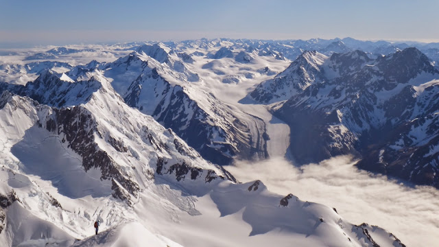
 |
| Route overview |
But first I needed to find a partner who was both competent enough for the climbing and fit enough for the effort. The first person I thought of was my friend Hamish Fleming.
Hamish grew up in Taranaki and had a strong background in multisport and adventure racing. He had raced hard for a decade, achieving great results, before discovering the mountains. He got hooked on back-country skiing, paragliding, and mountaineering.
As soon as I mentioned the idea for a 3000m peaks link-up, he was in. This was what he and I both needed, a project to put our energy towards. The next day he booked his five weeks leave and it was on.
Between our commitments, we had 34 days to work with. Would that be enough time to climb all 24 peaks? Time would tell. In the Southern Alps, weather is everything. But that didn’t faze us. It is the uncertainty that makes a great adventure.
Stage 1: The West Coast Peaks
Copland > Sefton > Strauchon > La Perouse > Empress hut.
Starting the expedition virtually at sea level on the West Coast had an excellent vibe. True to character, the first five days were scheduled to rain. We wondered if it was even worth setting out, should we delay? But we couldn’t afford to lose any time. Hamish looked closer at the radars and spied a short weather window on the second night. It was worth a shot, and we were hungry to begin.
 |
| Starting out at the Copland Track. Photo: Beate Manguse |
After a wet walk to Douglas Rock hut and a long sleep-in, we slammed coffee & oats at the unusual time of 3:30pm and hit the bush prepared for a long night. For all our optimism, the clag never cleared and we began to learn our first lesson: accept, and embrace.
Climbing Mt Sefton from the Copland is a great transalpine-mountaineering journey. You climb from the river valley, through steep bush, snowgrass slopes into big, glaciated terrain. It’s not technically difficult, but it’s a long committing climb from the valley with over 2,500 metres of elevation gain.
We ascended through a relentless west coast mist. Sub-optimal conditions, but what can you do? When we reached the summit at 1am, we were saturated and freezing cold. Our jackets had turned into shells of frozen rain. We could hardly stop for a minute without shivering.
We arrived home at Douglas Rock hut by 10am after an 18-hour day, exhausted from a big first effort, finished off by some awful bush bashing down the Bluewater route. But now we had points on the board. We could unwind and recover for the next three days under heavy rain. The expedition had begun.
Our next challenge was to cross the formidable Copland River, which we knew had caused other parties minor epics, even with lower flows. NZ Hunter Greg Duley had given us precise beta for a crossing spot, but it was nowhere to be found – presumably under water.
The best crossing we could find involved a committing two metre jump down onto a rock island, and a tricky scramble out. Once onto the rock island, jumping back was impossible. The rock on the other side was polished and holdless. Hamish took his boots and pack off on the rock island, and desperately smeared his way up the other side. I tossed him the rope and we hauled our gear up, one piece at a time. Across, and committed.
 |
| Hamish leaping across the Copland River |
Once through the thick bush surrounding Jungle Creek, we received our first sight of La Perouse from the Strauchon. The Gulch face on the western flank was shining in the sun, 2,000 metres above us. The mountain had a real Himalayan grandeur about it. Aoraki appeared through Baker Saddle. It felt truly remote. The only way out of here was up and over this huge mountain.
We camped beside the newly minted ‘Lake Strauchon’, a recent appearance due to glacial melting, and rested for a midnight start.
Before dawn we were traversing the Southwest ridge towards La Perouse, a full moon gleaming over the western ocean. During these surreal moments, the pre-dawn fear dissolves into numbness; it’s difficult to process all that you are experiencing.
Daggering across the summit ridge of La Perouse was our first taste of that never-ending, exposed, grit-your-teeth type of classic mountaineering. It drilled into us the virtue of patience, where you simply need to take your time, for eventually you will get there.
The summit was spectacular, wild views of west coast wilderness and to the east, the Hooker faces of Aoraki, in my mind her most impressive aspect. Hamish had never climbed any of these peaks before. His Mount Cook climbing resume consisted of a walk-in to Plateau hut and a failed attempt on The Footstool, so he was seeing these places with fresh eyes. I leached off his enthusiasm.
 |
| La Perouse |
Far below in the Hooker glacier, Anna Keeling and Jane Morris were approaching Empress hut with their two clients, in preparation for a rare guided Grand Traverse. A storm was beginning to brew as they rounded the final icefall, and they heard voices above. Two figures were abseiling from Harper Saddle. ‘Where have they come from?’, they wondered, as they hurried towards the hut.
 |
| Mt Hicks and Harper Saddle |
What an excellent surprise when we all rendezvoused at the Empress hut door, relieved to be sheltered from the weather, with three days of storms ahead to exchange our stories. It is the people you meet in the hills that really make it special.
 |
| Friends at Empress, L-R: Hamish, Jane, Alastair, Linda, Nigel, Anna |
The storm at Empress raged for two days before slowly clearing on the third day. Fortunately, the 70cm of forecast snow mostly came as rain or blew away, prevailing perfect conditions for the next leg of our journey.
 |
| Empress Hut |
Stage 2: The Hicks to Haast Traverse
Hicks > Dampier > Vancouver > Malaspina > Magellan > Teichelmann > Graham > Silberhorn > Tasman > Lendenfeld > Haast > Pioneer hut.
The traverse from Empress to Pioneer was the most critical part of the project. If we could get through this section, we’d be in a great position, with an extra 11 peaks in the bag. It was also the section that filled me with the most fear.
Three months earlier, I had climbed a route on the Northeast face of Torres Peak with Pat Gray. From the summit of Torres after that hard day of climbing, I looked over to Hicks and traced my eyes over our proposed route along to Dampier, Vancouver, Malaspina, out to Magellan, over Tasman… So much terrain. I was filled with trepidation, almost to the point of reconsidering the whole mission.
But here we were, crunching out of Empress at 2am bound for Hicks with a three-day weather window ahead of us. Perfect. A short term memory is a mountaineer’s greatest asset.
 |
| Curtain Route, Mt Hicks |
Back up Harper Saddle, five pitches through the Curtain and we were on Hicks, 7am. Across to Dampier, gendarmes and hard ice, 11am. Feeling it already. A Patagonian rime pitch up Vancouver, sweltering in the sun, 3pm. Endless tedious & tricky terrain, Malaspina, 9pm. Time to escape, out came the Escaper, a few tugs and boom, onto the snow below Clarke Saddle.
 |
| Malaspina at sunset |
I spied a ‘schrund below Teichelmann and it turned out to be the perfect camping spot for the night. There was enough space to walk around in soft ‘schrund snow, so we could finally relax a bit. All of that exposed terrain had taken a toll.
 |
| Bivvy above Clarke Saddle |
Waking up at Clarke Saddle, the Aoraki sunrise was epic.
 |
| Sunrise over Aoraki |
We climbed straight out of the bivvy for an out and back to Magellan, then set our sights on the mighty Mt Tasman.
 |
| Magellan |
 |
| Towards Tasman |
Once you’re up high, even Tasman didn’t register much more than a bump along the ridge, and the numerous summits came relatively easily that day.
 |
| Mt Tasman summit |
At Marcel Col, however, Mt Haast did not look as easy as expected. Late in the day our motivation was waning, and the highest point of Haast was annoyingly far out along the ridge.
I do not always hold myself to the highest standard when in comes to summits. Oftentimes a technical climb will top out on a relatively high point of the summit ridge, but not the absolute highest. I’m usually happy to call it, I’m not a perfectionist. It’s a contentious issue in climbing. Perhaps it is a distinction between an alpinist and a mountaineer – one for the line, another for the summit.
On this challenge we were mountaineers striving for true summits and we surrendered to the geographical discipline of the mountain. Admittedly, there was something deeply satisfying about going to the absolute highest point of Haast that evening, especially since it required more of us than we felt willing to give. Ultimately, mountaineering is a game where you play by your own rules.
 |
| Walking down the glacier to Pioneer |
Stage 3: Pioneer Peaks
Haidinger > Torres > Glacier > Douglas > Centennial hut.
Safely ensconced in Pioneer with a fresh set of food, we felt the hardest climbing was over, we could relax a little. Was this optimism speaking? In reality, every peak had a little sting in its tail.
Haidinger threatened strong pre-frontal winds and tried its best to snag our abseil ropes as we fought out our descent.
Torres Northeast Couloir confused us in the moonless dark and route-finding mistakes wasted three hours. We did well to keep the mood positive, focusing only our next steps and not the wasted ones. We could feel the mental fatigue accumulating after the long exposed day coming off Torres West ridge, but took comfort in that the remaining West Coast peaks should be much easier…
 |
| Torres Peak summit |
 |
| Abseiling a step on Torres west ridge |
 |
| Descending Torres west ridge |
 |
| Sunset at Pioneer |
The hardest part about climbing Glacier and Douglas was the sickening midnight alarm, we had barely unpacked from Torres. We slept in until 2am and fortunately the climb and walk to Centennial passed without issue, and we felt much better having pushed through the fatigue to knock off another 2 peaks by mid-morning.
 |
| Climbing Douglas Peak from Glacier Peak at dawn |
 |
| Douglas Peak |
 |
| Douglas Peak rock step |
Stage 4: Centennial Summits
Minarets > Times > Elie De Beaumont > Walter > Tasman Saddle hut
Now things were taking on a transalpine flavour again. Hopping passes between glaciers, popping up peaks. We secured Minarets in the rosiest of alpenglows, before plunging off the map into the isolated Spencer glacier to camp at the foot of Mt Elie De Beaumont. Another peak which is so much more attractive from the west.
 |
| Minarets at dawn |
 |
| Minarets summit |
This was three days into four days of fine weather, and the signs of change were upon us. It was exciting to stand on Elie De Beaumont with her panoramic views west and north, witnessing the next storm slowly moving towards us. 19 peaks, 20 days. We could hardly believe it. Maybe the dream was possible?
Stage 5: Hamilton & Malte Brun
Tasman > Darwin > Hamilton > Bonney > Malte Brun > Turnbull > Tasman > Freshfield > Plateau hut.
Morale was high. We had arrived at Tasman Saddle after a solid four-day session from Pioneer, and a major deluge had set in. Three days in the pit was exactly what we needed. Then more good news arrived. Five days of ‘acceptable’ weather was coming. Just enough time to clear the park.
Down the Tasman and up to the Bonney in thick murk, it appeared our more ambitious plan of linking the Hamilton - Malte Brun skyline ridge was off the cards. So we changed tack, dropped pack and attacked Hamilton’s ski line, up and back in three hours. We didn’t come for views we came for summits.
 |
| Mt Hamilton |
Now Malte Brun. I had unfinished business with Malte’s West ridge after a failed attempt nine years earlier on my first excursion in the park. Could this be redemption? Our camp below Bonney’s Rib sustained wind, snow and rain all night into early morning, plastering both our tent and the rock above with rime. We started to worry. So deep and so close, just one missed chance could spell the end of the dream.
Patiently we waited, and were rewarded. Signs of clearing gave us hope. 2pm was not a conventional time to start climbing, but this was snatch-and-grab time. The inversion layer descended and we found ourselves on Malte’s famed Cheval staring across the Tasman with only the peaks we had climbed floating above the clouds.
| Malte Brun summit |
 |
| Mt Elie De Beaumont from Turnbull glacier |
Stage 6: Grand Plateau
Aoraki/Mt Cook > Dixon > Cinerama Col > Ball Road.
That was close. Again we had squeaked through the waves of weather. Just two formidable peaks remained here, the big one, Aoraki, and little cousin Dixon.
We had familiarity on our side now, but the challenge was not muted. Strong north-westerlies were predicted, rising to 65 km/h later in the day. Before I could touch my midnight breakfast, something churned in my guts, and I vomited over the unfrozen glacier. So deep and so close.
Virus purged, Linda bound. Until now I had taken charge of all the technical climbing, but now it was time for Hamish to take over. He had served a fine apprenticeship over the past weeks and now I felt he was ready for the sharp end. Mentoring is such a valuable part of mountaineering culture, and it was amazing to see how much Hamish had progressed in this compressed period of time. Thanks to all the mentoring I have received over the years, Hamish could now benefit down the line.
Hamish led out the summit rocks with four quick draws and before long we stood on Aoraki. We looked out to the northwest, baffled that the winds had abated momentarily to allow our ascent. Threading back through the broken Linda, ice contrails vortexed over the summit ridge. Someone had surely been tinkering upstairs for us, it seemed.
 |
| Aoraki/Mt Cook summit |
 |
| Hamish jubilant on Aoraki |
One peak left in the park – Dixon. Again, strengthening winds in the forecast kept us on edge, and the following day would be a full storm. We only had seven days left to climb Dixon, bike to Wanaka, and climb Aspiring. This was the only chance.
Our strategy was to strike the Southeast ridge just after dawn, hoping for another morning lull in the wind. Our guts churned again this morning, but now only out of trepidation. Dixon also offers a tricky ‘schrund crossing, question marks always loom, nothing can be taken for granted.
But it was to be, Hamish led us through and we pushed head on into bolstering wind up the ridge. Pumped up and invigorated by the power of the storm, and full of gratitude for the mercy of the mountains.
Later that day, Hamish and I were staggering up the moraine wall towards Ball shelter when we spotted a girl jogging amongst the rocks way below.
 |
| Nearing Ball shelter. Photo: Beate Manguse |
It was Beāte! Hamish’s girlfriend. She had come out to meet us for our final walk back into civilisation after 28 days in the mountains.
 |
| Hamish & Beate embrace above the Tasman moraines |
She brought coke and beer, sandwiches and avocados and salad. Sweet nectar.
 |
| Near Ball Shelter. Photo Beate Manguse |
But most importantly, she brought our road bikes. Six weeks earlier, it had felt totally ridiculous to be stashing those bikes under the bunks at Wyn Irwin. Surely the chances of using these would be next to zero. But here we were.
Stage 7: Journey to Aspiring
Twizel > Wanaka > Matukituki > Bevan Col > Aspiring.
The nor’wester that had been brewing up on Dixon earlier that morning was now a full blown storm and a wind to our backs, whisking us along the banks of Lake Pukaki. What is this bicycle power, so swift?
Twizel by night, completing the Dixon-to-Twizel traverse and back on the saddle the following morning for the SH1 café crawl over Lindis Pass in pouring rain.
We had looked forward to this unlikely stage for so long, since it signified a reward for the completion of Aoraki’s 23 peaks, as well as a change of pace. Like some video game, we had been granted permission to complete the final stage of the quest and defeat the final master - Aspiring.
We rolled into Wanaka late that evening, sore in the saddle. One day of potentially fine weather remained before a week of unsettledness. We’d been on the go for six days since Tasman Saddle and felt quite fatigued, but the momentum could not stop now. The only option was to somehow summit Aspiring the following day.
We rose early, swapped road bikes for mountain bikes and ground out a very sleepy five-hour ride along the Matukituki road to Aspiring hut. Our faithful support crew offered drinks from the car window. We needed all the help we could get at this stage.
In the Matukituki valley we were shrouded in clag all day until, in dramatic style, we rose out above the cloud at Bevan Col to see our final mountain Tititea, Aspiring, standing tall. Morales soared.
It’s hard to describe the emotions on that final summit, because there were none. Despite the glorious, windless evening, I felt devoid of any feeling. I was simply too tired. We were also confused. Jetlagged. Aoraki was just over there, we could see it clearly. Two days ago, we were there. Now we were here. Everything had worked. Feelings would come later.
 |
| Tititea/Mt Aspiring summit |
 |
| Tititea/Mt Aspiring summit |
Conclusion
We felt extremely lucky to complete all 24 peaks in the one month. The critical factor was of course the weather. There were many times where the weather was only just good enough on that day to allow for an ascent, days where the weather cleared just in time, or held on for just long enough for us to summit or reach the next hut. Sometimes the winds seemed to abate up high for just the right moment, usually around dawn.
Perfect weather seemed to line up with technical or committing sections, and marginal weather seemed to line up with the easier peaks like Sefton, Hamilton, and Dixon. We summitted Mt Aspiring at 8pm on a fine evening, before the next four days brought wet, unsettled weather.
While some of this was luck, we also had to be opportunistic, plan ahead, keep pushing, and always give it a go. Climbing Mt Sefton through the middle of the night in light rain was unpleasant but proved to be crucial to later success. Failure or delay on any single peak would have pushed out the entire schedule, and ultimately, would have held us up short.
The 34-day time frame was arbitrary, and others may have more time available, however, we found having a fixed time frame added to the excitement of the trip, creating a sense of urgency. An unlimited time frame would take away some of that uncertainty, in the same way that any wall can be climbed with enough bolts.
The primary goal for this trip was not to complete all the peaks in one month or set a speed record, it was to experience an expedition in New Zealand. A deep immersion in the hills for an extended period. To connect with the mountain environment, watch the storms roll in and out, sense the changing of conditions, snow ice & rock, patiently wait for short opportunities to dash up to those high summits.
The goal to climb the 24 peaks created great motivation for us, but we also felt a tension between our determination to succeed, and not wanting to let that ambition push us to take unacceptable risks. The deeper you go, the more peaks you climb, the more you have invested, and the harder it is to turn back. You want to succeed, but you also want to survive. This is a common dilemma for the mountaineer, one that becomes accentuated in longer expeditions. These were the mind games that we grappled with.
Positive mentality was everything. Patience during the storms, breaking down the expedition into small manageable sections, focusing on next actions when mistakes were made, celebrating the small wins. This kept our morale & psyche high and helped us enjoy the whole journey.
What fascinated me most was the paradox of success. If we were to fail on just one peak, objectively the expedition would be a ‘failure’. However, the experience would be almost identical if we were to succeed on all 24 peaks.
So what do we really seek in an adventure? How do we bypass the allure of glory & achievement, and why do we find it hard to accept a near-success-failure? It is the ambition that motivates us, drives us, allows us to accept suffering. We all enjoy striving towards a goal. Ambition creates the desire and ultimately the adventure and the journey. We must learn to accept the tension between these that plays out in our minds.
Success of the goal is merely a façade for the real meaning of the journey, which I believe is to learn, grow and develop greater connections with your partners, the environment and yourself. But this is all much easier said than done.
BETA
The Route
There could be many different possible route options to link up the 24 peaks. I thought it made most sense to start with starting with Mt Sefton, traverse north and finish out the Tasman. Here is a overview description of the route we chose.
Stage 1: The West Coast Peaks. The journey began on the west coast. Up the Copland valley to climb Sefton via the West ridge. Into the Strauchon valley, ascending the SW ridge of La Perouse, descending northwards on the main divide route towards Harper Saddle and Empress Hut.
Stage 2: The Hicks-Haast Traverse. A 2-day traverse of 11 peaks, the Hicks-Haast traverses from Hicks to Dampier, Vancouver, Malaspina with a camp above Clarke Saddle. An out-and-back to Magellan, followed by Teichelmann, Graham, Silberhorn, Tasman, Lendenfeld and Haast, descending from Marcel Col to Pioneer Hut.
Stage 3: Pioneer Peaks. Day ascents of Haidinger (South ridge) and Torres (Northeast couloir), Glacier and Douglas, travel across the Fox & Franz névés to Centennial hut.
Stage 4: Centennial Summits. Minarets, followed by a descent into the Spencer Glacier, to climb Mt Elie De Beaumont from the west, via the Walter-Elie Col. Descent via Mt Walter and Divers Col to Tasman Saddle Hut.
Stage 5: Hamilton & Malte Brun. Hamilton from the Bonney Glacier and Malte Brun via Bonney Rib and West Ridge. Turnbull Glacier to Tasman Glacier, Freshfield Glacier to Plateau Hut.
Stage 6: Grand Plateau. Aoraki/Mt Cook via Linda Glacier, Dixon via Southeast Ridge. Cinerama Col, Boys Glacier to Ball Road carpark.
Stage 7: Journey to Aspiring. Road bike from Ball Road carpark to Wanaka, mountain bike from Wanaka to Aspiring Hut (283km total biking), ascend Aspiring via Bevan Col, Northwest ridge.
See the route map here.
Daily Itinerary
1. Copland valley > Douglas Rock hut (7 hrs).
2. Rest morning, start climbing Mt Sefton at 4pm > Welcome Pass.
3. Summit Mt Sefton 1am > Douglas Rock hut 10am (18 hrs).
4. Rest day (storm).
5. Recce Copland river crossing and rest.
6. Douglas Rock hut > Copland river > Jungle Creek > Strauchon glacier camp (6 hrs).
7. Strauchon glacier > La Perouse Southwest ridge > Main Divide route > Harper Saddle > Empress hut (13 hrs).
8. Rest day (storm)
9. Rest day (storm)
10. Rest day (clearance)
11. Empress hut > Hicks > Dampier > Vancouver > Malaspina > Clark Saddle camp (20 hrs).
12. Clarke Saddle camp > Magellan > Teichelmann > Graham > Silberhorn > Tasman > Lendenfeld > Haast > Pioneer hut (16 hrs).
13. Pioneer hut > Haidinger South ridge (6 hrs)
14. Rest day (storm)
15. Rest day (storm)
16. Rest day (storm)
17. Pioneer hut > Torres Peak via Northeast couloir > descent via West ridge to Katies Col (16 hrs).
18. Pioneer hut > Glacier Peak – Douglas Peak > Centennial Hut (8 hrs).
19. Minarets > Styx glacier > Spencer glacier > Times glacier camp (9 hrs).
20. Times glacier camp > Elie-Walter Col > Elie De Beaumont > Walter > Divers Col > Tasman Saddle (9 hrs).
21. Rest day (storm)
22. Rest day (storm)
23. Rest day (storm)
24. Tasman glacier > Darwin glacier > Bonney glacier > Mt Hamilton > Bonney glacier camp below Malte Brun (9 hrs).
25. Bonney glacier camp > Malte Brun West ridge via Bonney Rib > Bonney glacier camp > Turnbull glacier > Tasman glacier moraine camp (9 hrs).
26. Tasman glacier moraine camp > Freshfield glacier > Plateau hut (9 hrs).
27. Plateau hut > Aoraki/Mt Cook via Linda glacier (10 hrs).
28. Plateau hut > Dixon Southeast ridge > Plateau hut > Cinerama Col > Boys glacier > Ball road end > road bike to Twizel (15 hrs).
29. Road bike Twizel > Wanaka (8 hrs).
30. Mountain bike Wanaka > Aspiring hut > Bevan Col > Kangaroo Patch > Mt Aspiring Northwest ridge > Colin Todd hut (19 hrs).
31. Colin Todd hut > Bevan Col > Raspberry Flat carpark (6 hrs).
List of peaks in order
1. Mt Sefton
2. La Perouse
3. Mt Hicks
4. Mt Dampier
5. Mt Vancouver
6. Malaspina
7. Magellan
8. Mt Teichelmann
9. Mt Graham
10. Silberhorn
11. Mt Tasman
12. Lendenfeld Peak
13. Mt Haast
14. Mt Haidinger
15. Torres Peak
16. Glacier Peak
17. Douglas Peak
18. Minarets
19. Mt Elie De Beaumont
20. Mt Hamilton
21. Malte Brun
22. Aoraki/Mt Cook
23. Mt Dixon
24. Tititea/Mt Aspiring
Gear
Lightweight gear was crucial for the trip, but gear also needed to be durable enough to last a month of constant use.
Our pack capacities were 40L and 50L. The most amount of food taken was 8 days for the first day walk in, otherwise the maximum amount of food carried was 3 days. Many ascents were day trips from huts, or 2-3 day traverses between huts with re-supplies.
I wore a one-piece thermal suit with light rain pants (Macpac Nazomi), a hooded long-sleeve t-shirt (Macpac Hooded Eyre), hooded thermal (Macpac Prothermal), light mid-layer (Macpac Nitro), rain jacket (Macpac Nazomi) and down jacket (Macpac Arrowsmith). Visor cap underneath helmet (Petzl Sirocco), buff, thin leather gloves (Macpac Dash) and waterproof gloves (Showa Temres 282-02). No spare clothing was taken for huts, this was fine since it was rare to be wearing all 3 thermal layers so 1 layer was always dry.
Lightweight (~400g) sleeping bags were used (Macpac Firefly 200) but these were compensated by warm down jackets (Macpac Arrowsmith).
A few key contingency items were taken – an extra pair of sunglasses, and a spare headlamp.
A light set of avalanche gear was carried given the summer season – transceivers and 1 shovel for the team. The shovel was also taken to prepare camping spots and snow caves.
The rack was adjusted at different stages of the trip. We started with just glacier travel kit, 3 ice screws and snow-stake for Sefton & La Perouse. At Empress we picked up an extra 4x ice screws, 4x cams #0.4-#1, 7 nuts, 1 knife blade piton, 6x 60cm draws for the more technical Hicks-Haast traverse. The full set of 7 ice screws was useful on Hicks, Vancouver and Tasman. At Pioneer hut we had 4x ice screws flown out with climbers in the hut (spontaneous), but we kept the rock gear as it would be used on Douglas, Walter and Malte Brun.
We used one 8.1mm half rope. On moderate snow & ice we used the rope as a single strand, but usually we doubled the rope and climbed with two 30m strands when pitching or simul climbing. One Petzl Tibloc each for crevasse rescue and simul climbing. The Beal Escaper device was very useful in some situations to do full 60m abseils with the one rope, as long as it was a straight pull without too much loose rock or rime to get stuck on.
A 2-person single-skin tent was used on 5 nights during the trip. Half-length sleeping mats (ThermaRest Z-lite Sol) were combined with internal pack foam padding (Macpac Pursuit 40L).
 |
| Relaxing in the tent on the Times Glacier |
For navigation we used phones with the NZ Topo50 app, assisted with Coros Vertix GPS watch providing altitude/distance and a map navigation feature.
A Garmin InReach Mini was used for weather forecasts and communication. The other person would carry a PLB for contingency. Electronics (satellite phone, phone, headlamp, watch, camera, battery banks) could all be charged at the huts which are equipped with solar panels.
See here for a full gear list.
Food
Each food drop contained about 7 days of food each. This was to allow for 3-4 hut days in addition to climbing days. Most alpine huts were also well stocked with hut food. Some drops were made up to 2 months in advance, but all food including cheese was still in good condition. Different types of food were allocated for hut and climbing days - higher fat & protein savoury foods for hut days and higher carbohydrate foods like muesli bars and GU for on the move. Favourite foods were cheese & salami wraps fried in coconut oil. Pots and pans in huts could be arranged to create a frying pan setup over the Jetboil stove. Radix Expedition range meals were eaten for all dinners, providing great nutrition and no digestion issues. A Jetboil was used rather than a liquid fuel stove in this case due to its lighter weight and ease of use in the tent. Used gas cannisters were flown out from huts with other climbers, a luxury that does not exist on traditional long transalpine trips where rubbish accumulation is more of an issue. Snow melting was rare since most nights were at huts with water tanks.
Logistics & Support
The biggest logistical challenge is arranging food at each of the 5 alpine huts in advance. To avoid the expense of helicopters, we managed to fly in 7 days of food each to Pioneer, Centennial, Tasman Saddle and Plateau either by ourselves on prior trips, or with friends we knew already going to those huts. Empress hut is a no-fly zone, so 2 weeks before the trip Hamish & I carried in 7 days rations and some extra technical gear.
Hamish’s girlfriend Beate dropped us off at the Copland valley trailhead for the start of the trip.
We appreciated having a support crew for the cycling from Mt Cook Village to Aspiring. Hamish’s girlfriend Beate met us at the Ball road carpark with our bikes and cycling equipment, drove our climbing gear to Wanaka and stopped periodically to provide food/water/clothes on the 3 day bike ride. We stayed in accommodation in Twizel and Wanaka.