Featured articles

Showing posts with label Canterbury. Show all posts

Sunday, 6 May 2012

T'Walk 24 Hour Rogaine

60 seconds is a long time. 60 minutes is a longer time still. But 24 hours? Twenty four hours spent enduring punishing but spectacular terrain in the Canterbury backcountry? Now that's what I call a good time.

"JAFAS" - surrounded by 49 South Island teams we decided to be Auckland proud
 Sharon Hornblow came at us back in April pushing AUTC to enter a team into a 24 hour epic rogaining/orienteering race organised by the Canterbury Uni Tramping Club. "Come do the TWALK!", she said. "Otago teams have been dominating for too long, we need some northern blood to shake up the competition."

 We were keen from the outset, and with cheap flights appearing through the woodwork there was no excuse. Christchurch for one weekend seemed extravagant, but sometimes in life you need to be impulsive. This was one of those times. Coated in a crunchy red shell and loaded full of chocolate and Powerbar, Team JAFAS stepped out of the bus into our much-awaited mystery location: Lake Coleridge.


Lake Coleridge appears...

Saturday morning, 50 teams in flourishing and hilarious costumes were deposited with maps on the road-side just over Porters Pass. Our first mission was to navigate ourselves to the Hash House nearby Lake Coleridge. Hash house... a special woolshed churning out an eternal supply of food thanks to some special volunteers. A constant flurry of food appeared... hot lasagne, fresh pizza, chunky soup, warm muffins, coffee, cereal, sandwiches... this was our main driving source as we collected the first 16 checkpoints hidden in boggy streams, under thick matagouri scrub, rocky outcrops on scree slopes, and generally in the most difficult and awkward locations.


White peaks in the distance feed the Rakaia River - the northern strains of the Southern Alps

But our rewards were in the form of spectacular Canterbury scenery, new vistas appearing around each corner. On the dry scree tops the autumn sun was scorching, and after the opening fanfare of costumes wore off we soon found ourselves peeling off awkward kid-sized helmets, James packed away his straw sack, and Helen itched at her face paint. All thoroughly worth it though. Our self-inflicted inconvenience seemed insignifcant compared to carrying a giant paper-maché Donut on your shoulders as one pair impressively pulled off. Delicious.

"Immerse yourself in toxic waste"

Navigating on the 1:50 000 topographical map was difficult, even one contour line represented 20 metres in height change - in reality this was quite a decent sized feature, with little more detail to help us narrow down the location. Luckily, the good folks setting the T'Walk (pronounced "twork") had provided us with a set of incredibly useful cryptic clues. "Mucking around with mason" translated to a small muddy, rocky stream gulley in an otherwise featureless hillside. "Follow the bees from the door to the coleslaw" meant us to follow the fence posts from a farm-gate to a cabbage tree - we found the plastic token at the base of a fence post just after brutalising an innocent cabbage tree. Ironically, the clues only made complete sense after the clue was found, at the very least this made for a long slightly frustrated sigh at the cleverness of the setters.
 
Fading to dusk, making the most of the last of the day light
One of the highlights was surely the arising of the supermoon - a full fifteen percent closer - the glowing round slowly revealed itself from hiding beyond the Craigieburn Range. Our shadows were tossed across the tussockland at the low moon angle, so bright that our head torches were mostly useless except for clue-searching. So we kept the moon as our guide as we carried on with the never-ending mission... into twelve hours of night.  

The peregrine moon comes out to play
Before long, the buzz of the moon stars and mountains wore off and we found ourselves heading towards a depressing three-clue losing streak. There's only so long you can bare to wander aimlessly around an empty plateau searching for a clue as cryptic as "Ready to rock and turning dirty, in between some humping". Eventually you need to give up - always a very tough call - but often the clue is found on the way out! We had to show some patience though, because as we slipped further and deeper into the night, a rapidly dwindling patience would leave us exhausted as well as empty handed...


It wasn't all bleary-eyed misery in the hills however, Rogaine karma did serve us our fair share of luck in return for our perserverance. Following the distastrous run, we stumbled across a string of five easy clues that sent us flying out of Leg 2, into the Hash House, for a luxurious pre-midnight feast.

Jafa helmets made excellent bowls


11:30pm - heading out for Leg #3
We had timed it perfectly, even as if to a plan. In Auckland we had debated whether we'd need tents, winter sleeping bags, sleeping mats... as we left the Hash house woolshed nearing midnight, it dawned on me that Leg 3 would keep us entertained until dawn at least and rule out any opportunity for sleep. Besides, who could sleep when there was work to be done! At a glance, the route would send us climbing 600m over Carriage Drive Saddle, a long sidle around Cottons Sheep Range to Lake Selfe and back via  Little Mt Ida through swamps, powerlines, and ever-ending gravel road before breakfast.

The 20 hour freakout face

Fog had moved in behind the Peregrine shiner, this not only reduced visibility but forced me to extrapolate my mountain tops before I could take any compass bearings. Its a hard time navigating in the dark, sleep-deprived eyes wander from the map to the back of my eyelids, every so often an uneven step on the rough ground jolted me to focus. As much as 16,17,18 hours of constant walking and jogging sent us into extreme bouts of fatigue, the relief and joy of every checkpoint that we discovered was all the more intense. As we stumbled upon a huge green water tank we all laughed, and groaned - why? Searching far and wide for the "Incredible Hulk", our exhausted imaginations could only envision an abstractly shaped bush or tree...

Fog and sleet in the early hours, Sylvie powers on
 
Celebrating the coming of dawn!

 Its always a special experience, witnessing the slow arrival of dawn. Although fog delayed the 7am rise, it was the same fog that kept us relatively warm all night stalking the fields. We were prepared for snow, almost hoping for snow, giving full respect to the potentially freezing Canterbury high country. Sunday morning was a different story. After a brief scoffing session of cold porridge and hot coffee (anything tastes good after a hungry night), we emerged into a glorious mid-morning arena.

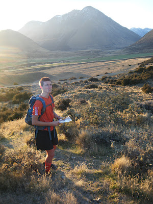
Sylvie lining up the map with the features

  We came into the competition with low hopes of competing, but this changed suddenly when we realised we were holding 8th place. With little over two hours left to salvage as many points in Leg 4 to hold our position, we dug deep and flung ourselves at four more controls: all or nothing. The mood was tense, we needed to be swift and navigate accurately, no messin' about. One eye on the compass needle, one eye searching for the clue, you can imagine the nerves...

Stumped in the crucial final minutes...
 Over the course of the past "day" we had developed a cunning technique of communicating within our team if we had found the clue or not. With 50 fellow teams scouring the same countryside as us, our competitive spirit couldn't afford to give out any hints... With forty minutes on the clock to finish, we were cutting it fine to find the "Queen Flax" in one annoyingly flax-filled field. The moment that Helen heard her call - "let's go Scarlet", Sylvie was beckoned with "I think we'd better leave this one, Amber", and James - "enough searching Roberto, time to bail" - everyone slid on a silent smile. Our 42nd control was bagged and the Hash house was soon in sight...

Big country - steep scree slopes crumble away from the ridges


 AUTC T'Walked into the woolshed proud, 23 hours 39 minutes after the starting stapler had set us charging all those hours ago. For Helen & I, this was our first 24 hour endurance event, something that had seemed huge and daunting in theory. James & Sylvie shared stories of blisters, accidental sleep-ins, midnight gut hurlers and more - obviously we were enticed to put our feet to an honest twenty-fourer. It was with huge grins that we four slept on the pebbly yard waiting for the bus, baking in rich Canterbury sun.

Each colour represents a different leg of the journey and a quick feast at the hash house


Check out the results from T'Walk 2012 here. We were stoked to score 2nd in the student team section and 9th overall. The sleep deprivation made the extra difference, although we severely paid for it in the week to follow... T'Walk 2013 - we'll be back!


Friday, 20 January 2012

Arthurs No Pass - to the Brink & Beyond

Arthur's Pass was the destination, Three Passes was the goal. Though as plans warped and moulded to the weather, the trip took on a very different flavour to what we were expecting... all for the better!


Arthur's Pass National Park marks the northern head of the Southern Alps, hills turn to mountains, things get serious. In terms of mountaineering, Nelson Lakes is home to some good training climbs for the more treacherous climbs in Arthurs Pass and Aoraki-Mount Cook. Lacking the experience to give impressive peaks like Mt Rolleston and Mt Armstrong a real shot, we headed in to scope out the alpine brothers. 


We arrived early for our wilderness meal, so to keep our appetites at bay we nibbled on a taste of Foggy Peak climbed from Porters Pass par entrée. A cool Speights at the Summit? We're in south now, would be a crime not to! It was a well deserved treat after two hours spent fending off 120km/h winds and sonic sprays of hail to reach the 1730m high point. Luckily, in the past others had been driven to the ground by gales on the exposed ridge too, and had built us rock shelters at vantage points along the route. We retreated from the summit with our hands shielding our faces from scree particles, and a fair dose of wind burn.

Craigieburn Forest was our campsite for the night - we were reacquainted with our old friend The Kea. How I'd missed him. What a relief to find the car's rubber linings still in tact after a night filled with squawking Keas.


Rivers were still "burly" when we finally made our entrance to Arthur's, so we left the Waimakariri to down-brew while we made our assault on Avalanche Peak. The climb was saturated with magnificent views of Mt Rolleston crowding the backdrop. The route from Avalanche Pk along the ridge behind me seems straightforward in summer... but hidden from sight is a 30m vertical face to be negotiated. Serious stuff.

I was plagued with regret having not brought the tent, to spend a night on a tussocky flat section below the peak would have been fabulous. Instead we spent two hours sleeping on the high plateau, dwarfed beneath Mt Rolleston.


By Tuesday the rivers had finally receded, so Ben & I tackled the Waimakariri river traverse. Mostly easy going along the wide glaciated valley flats, but further upstream the river gorged forcing us to cross each of the half dozen braids. We paired up for the wilder torrents, and with Mt Harper and Mt Speight dominating the end of the valley, we successfully made it to Carrington Hut. Filled with hot, sweaty DoC workers, and now 5pm there was no way our day was over just yet...


Reading the hut book warned us of the short yet difficult passage to come... "If you sleep in and start your tramp at 1pm arriving at Carrington by 5pm it would be foolish to think  that you would be able to reach Barker Hut before dark... If you decided to attempt such an adventure you would most likely find yourself camping just below Barker Hut on a ROCKY outcrop and returning feeling like a LOSER  but thankful to be ALIVE. We speak from experience..."

Considering that it was now 6pm, we were determined not to suffer their same misery - 7 hours in we'd still have to move fast, and stretch the daylight hours to the limit. The route along the rocky White River was almost non existent, and as the darkness closed in the cairns began to blend into the sea of boulders. With dusk came a showcase of colours etched into the cool sky beyond Mt Carrington. Colours morphed, intensified and faded with each weary turn of the head.

Mountain Art - Dusk on White River

All the while, we could see our goal - Barker Hut - neartly perched on the huge rocky buttress at the end of the valley. As we finally neared closer and began the last climb, our hearts sank. We had reached what would later be infamously referred to as: The Chasm of Doom. Each of the three hanging glaciers above Barker leaked gushing tributary flows into the main White River - the Cahill glacial stream had gouged out a deep chasm now filled with white water.

Our final obstacle, we scoured the banks for a safe place to cross. 9:30pm, night vision weakening, we helped each other across the thigh-deep current, making sure each foot placement was secure - a firm forearm grip, and Ben pulled me onto land. Our adrenaline was racing now, even though we'd crossed quite safely. Now it really was one big push to top out on the 100m high outcrop - relief. Ben climbed up a few minutes later, and was ecstatic. 10:15pm, almost twelve hours had elapsed when we finally opened the wooden door to Barker Hut.


In the morning we were able to take stock of what a prime location the hut was in. Three high glaciers poured into the gorges flowing around the hut's rocky foundation. From the hut we eyed up the four painful hours of river-bashing that had consumed late last night. From the 3-walled toilet, my eyes followed the White Glacier to 2300m, where Mount Murchison - highest in Arthurs Pass - claimed his spot one hundred metres above.

Prime Real Estate


After sleeping off our mountain hangovers, Ben & I set off to explore the route to the base of Murchison. While lunching on a moraine spur, we scoped out the ascent along the leading ridge to Kahutea Col, where snatching a summit would be simple. We made it to the snowline, a rock dislodged, I sprained a thumb... Sunbathing on the glacier seemed like a far better idea. And so it was. You can't be epic all the time.

Ben soaking it up at the base of White Glacier
Braving a dip in the Barker Tarn
As our final night at Barker Hut dimmed, we watched misty cloud passing over Harman Pass way below, and creeping our way... minutes later, our screens were blank. Minutes later, the white-out had passed. Hours later the hut rattled furiously and shook at its supports - a fantastic shelter for Cantabrians - the whole night wind powerful as a magnitude 7 earthquake blitzed Barker to oblivion. For once I was glad not to be in a tent.


Suited up in full weather gear, we braved the return journey with the assurance that we knew the route. Misty rain accumulated, and the rivers rose noticeably, so to cross the Taipoiti we jumped in the 'Clough Cableway' keen for a novelty crossing. This ancient piece of machinery was built to remember a 16 year old who had died crossing the raging White river. As it turned out, the machine was more dangerous than crossing the river by a long-shot!


Three thick iron cables hung across the 30m wide river, holding a small cart to be manually winched across. It was great flying across the river, the cable whizzing past my face, rain in my face, river gushing way below. Not so great was getting my hand caught between the pulley and wire - if I wasn't wearing gloves my hand could have been seriously injured. My screams to Ben across the river were drowned out in the rain. Luckily he was tired and released the winch, not a second too soon...


Somehow, the return trip still took just shy of 12 hours. Mission and a half! Returning to Nelson along the West Coast completed our deluxe South Island tour. This was Ben's first real taste of South Island tramping, he bravely pushed himself to his limits, and was hugely satisfied with the trip. Though when he returns, he'll more likely be gliding than tramping!

Arthur's Pass - a great place for everything

Saturday, 3 December 2011

St James Rogaine

For my third weekend based in Nelson I was keen to get out a bit further afield, beyond the bordering Richmond Ranges. Also, this weekend was rearing all over the country with mountain events - from the south, the glamorous Kepler Challenge 60km run in Te Anau. To the north, the infamous GOAT 21km around Ruapehu guaranteed to chew up your shoes, if not your soul. I had been looking forward to the Goat all year, but the Cook Strait proved too much of a logistical challenge. Plus, I was in the South Island already...

No Goat this year
I found my revenge in the form of the St James "Office Hours" 7-hour Rogaine held in the ranges beyond Hanmer Springs. Although I couldn't find a team mate in Nelson, I didn't give up. I took a gamble, and made the 300km journey to registration at St James Homestead hopeful, and nervous, to find a team... Success! The gamble paid off, I joined up with Elisha Nuttall and Joel Smith from Canterbury and Otago, and we made the ultimate team.

Elisha & Joel rearing to go at briefing
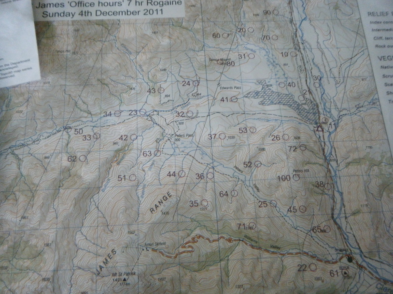
THE MAP
High above the steamy Hanmer Springs, we were now in real Canterbury high-country, and the most incredible terrain for a rogaine I'd ever seen. Take a patch of North Island farmland, add some towering 1800m mountain ranges and braided river valleys, and you get the idea. A nor-westerly was threatening us with rain so we packed for the conditions, carrying a stash of Gore-tex and merino. Joel scoffed at the briefing and repped a cotton tee-shirt, the whole day.

First up the first hill, foolish but necessary
9:30AM: The horn sounded. We darted up the nearest knoll-top for our first 10 points of the day. We were in the lead. Our strategy was to start out with some flat controls to start the day at a good pace, we headed north and pick up up 7 more controls without much trouble. The second most-valuable control in the far north had a pot of jelly-beans at the flag, we were delighted. To be my downfall or not, this lead to me ditching my salami sandwiches, chasing a sweet-toothed sugar craving all day. Only one hour had passed, how long would I last?

Jelly Beans. Yummy
Rugged high-country terrain
We had a horrible time finding #60 perched on a saddle above Horrible stream - I was convinced we were at the right saddle and high point combination, but there was good reason why the compass didn't agree... Determined to make up time, we raced on to catch up the school team who had ashamedly crept past us.

Cresting the rocky spur to #70
After following the easy ridge up to Samoa Mound, we crashed down a scree slope into the valley heading west. We cruised through 5 easy controls, before filling up water in the DW stream. The terrain was extremely rough and made running hard at the best of times. We pushed straight up the hillside to collect #62, and while sidling round to the next stream gulley we met eventual winners Chris Forne and Nathan Fa'ave climbing in the opposite direction - clearing finding it hard work too!

Marshy, wide valleys to the west
Big scree covered slopes
With time ticking rapidly towards 7 hours, we had to start lowering our expectations, and we dropped four controls high on the St James range. We were saving our climbing energy for the big 100 pointer atop Peter's Hill - number-one priority in our race plan. We cleared the swampy Peters Valley of the low controls and made a late dash for the summit! 1 hour 20 to go...

Battling the weather to summit Peter's Hill
The rain that had held off all day finally made its presence known, and at 1100m above the valley plains we felt its full force. Joel, still hugging his cotton t-shirt and not much else, didn't complain, all eyes were focussed on avoiding the prickly matagouri scrub and searching through the mist for the orange-white control flag. Boom - there it is: we punched our wrist bands and scrambled into the final stream gorge to find #72. The clue seemed straightforward: "Base of rocky outcrop/spur".

Only a few obstacles before us to conquer
We spent 20 minutes of precious time searching the steep stream banks to find no said rocky outcrop - the 7-hour countdown was racing, find it or flee! One last desperate attempt for a valuable 70 points, we charged down the gorge to try and find it en-route to the finish checkpoint. There it was! For once it was the map who was wrong! By now we didn't care, and battled through the shrub up & over the spur to descend to the road - five minutes to go - three of us ran the final kilometre towards the finish, with a generous helping of seconds left in reserve.

FINISH.
6:58:34
We almost cramped stiff after stopping in the rain. Back to St James homestead for a few moist sausages cake and tea - no better way to finish an awesome day in the hills. Even better was the luck of finding such mint team-mates - Joel & Elisha were solid all day - even though we're spread across the country we'll definitely meet up for some adventures in the future...

Nathan Fa'ave and Chris Forne powered their way through the course to pick up 1620pts from a pot of 1710. Impressive stuff from the adventure racing & orienteering champs. We were happy with our collection of 1200pts, and picked up an iced Christmas cake for our efforts. Thanks to Grant Hunter and the team at NZ Rogaine Association for organising such a sweet event.