Featured articles

Saturday, 3 September 2011

The Hillary Trail

Running in the Footsteps of Sir Ed


The Hillary Trail is a 75km route through the Waitakere Ranges, beginning at Muriwai Beach in the north to Arataki Visitor Centre in the south. The trail opened in January 2010 to honour our national kiwi hero, Sir Edmund Hillary. The trail has been special for me since, I ran the Arataki-Piha half on January 8th with a group to arrive at the opening ceremony held on the 2nd year anniversary of his passing to mountaineering glory. A year later, I ran with seven others the full trail for the first time in 14 hours. The trail is just too good to make it an annual bash - a further six months down the track I decided to team up with Kristian Day of Napier to take on the trail again for real.

Peter Hillary, Timothy Burrell, Me, Sarah Hillary - Jan 2010
But we didn't want to make it too easy.
North - South: evil hills saved for the finish.
Unsupported: no cars following us with watermelons, we'd have to carry our own soggy crumpets.
Winter: mud. Enough said.

With no fanfare to blast us on our way, we climbed from Muriwai Beach through backstreets to the beginning of the Te Henga trail - a jewel of Auckland's west coast. Myself and Kristian were joined by Gene Beveridge and Matt Ogden for this first 10km stretch, they were keen for an early morning bash. At least after some thorough persuasion. They set us off at a solid pace that we dreamed was sustainable for the whole run, but when they left us at Bethells Beach we slipped into our own rhythm. Initial nerves shaken off, and Ruahines damage report coming up clean, we moved through the iconic sand dunes and around Lake Wainamu smoothly.

Te Henga trail
Our first major climb up the Houghton track broke a decent sweat, now 8am I topped up my breakfast of oats with some syrup-marinated crumpets while slipping up the gulley. We almost had a close encounter with the infamous Houghton Boar - rollicking, crunching and snarling in the mud, hidden from sight - we didn't stick around! I collected a tag at Wainamu junction, one of last remaining from the Bethells 12-Hour Rogaine held in July, good to see the event organisers are cleaning up after the festivities.

Piha Appears!
Kuataika was a fun downhill blitz en route to Anawhata farm and once a large group of Japanese hikers filed passed us on White track, Lion Rock burst into view - Piha in only 3 hours 40 mins! We were stoked at the split. Striding along Piha Beach felt great, too great, we pushed the pace to Glen Esk to enjoy our 8 minute lunch break, lying on the grass, in the sun... Bliss.
Kristian feeling spritual at Kitekite
And off again - a swim at KiteKite falls was tempting, very tempting, but if we were to beat Nick Harris' 11 hour record, some sacrifices had to be made! We crested to Piha Rd for the road bash towards Karekare, but not before making a costly mistake following the trail markers... Note to self: always bring map! Kristian was psyched to see the marker after an extra half hour of unnecessary knee-crunching along the road.


We'd taken a blow to our morales, it felt like playing catchup now on lost time, so we barely stopped for a photo of the map at Karekare beach before the next climb to Mt Zion. This is listed on PeakBagging.co.nz, coming in at 272m it gave us just enough height to take in the wild coastal strip. Whatipu beach is an enormous land of swamps of sand dunes, with a roaring surf. The winter rains had taken their toll making the cliff tracks to Whatipu were muddy and energy-draining: our blistering pace from the morning was slowing!

Kristian pelted by rain up to Whatipu trig
It was a different experience along the windy ridges of the Omanawanui track today: a ten hour fatigue meant I was stumbling up the hills and my vision was a mad blur on the downhills. I finished my last food supplies at Karamatura forks - dangerous - there were still 3 hours to go. Fortunately, this was no average food - my energy rich Al's PowerBars gave birth to a second wind that blew through just in time to destroy the 400m descent into Huia, and we enjoyed telling other trampers what we were up to along the way.

The ever sensational Omanawanui Track

Gritting his teeth along Puriri Ridge Track
But at Huia reality dawned (or rather dusked), and the truth came out. We were absolutely smashed and still had 2 hours of muddy climbing to the finish. The transition from walking to running was slower than a freight train pumping its pistons and rolling into a start - it was becoming an increasingly mental challenge just to get going. And worse, our chances of beating Nick Harris' record were sinking into the creamy Nihotupu mud...

One ofthe many 'final' climbs to Arataki
Twilight darkened under the canopy of bush, straining our night-vision until we finally gave in to sense. Every effort was magnified, even getting out the headlamp. Luckily I'd thrown one in at the last minute - we weren't expecting to go into the night. It was a bonding experience for me and Kristian as together we pushed through extreme fatigue into the never-ending darkness, rain and mud...but eventually we heard a noise, a light - a Ruby Muir! Our faithful support crew had been traipsing around the trails for 3 hours never knowing when we might arrive. Thanks Ruby. Once we hit Slip track it was one final surge for an emotional finish in 11 hours 56 minutes.
Although we didn't beat Nick's time, we were still stoked with our effort. We'd completed the 2nd ever unsupported traverse of the four-day trail in half a day, through some tough winter conditions. I love the Hillary Trail, but for now I don't want to see the trail again for some time!
Smashed, Ravaged, but Finished
Now that the we have conquered the Hillary Trail in both directions (North-South is definitely harder by the way), there is only one thing left to dream of...

Double Hillary...?

The Hillary Trail

Thursday, 1 September 2011

Rampage in the Ruahines

Of Mi-Goreng and Mountains


Ruminations of a rollicking rampage through the resplendent Ruahines…
August 28th - September 1st 2011


Day One - I began the first day with a debut run in Matt Ogden's Red 1 course at Woodhill Forest, a good two-hours of intense orienteering. Matt set a challenging course, I stumbled into the course with a 15 minute catastrophe at the start. But I soon got my eye into the map and knocked off the rest of the course relatively cleanly, though slowly compared to Duncan Morrison's blistering 59 minute win.


I was inspired to venture to the Ruahines after watching this mesmerizing helicopter fly-over of the ranges. "I need to check that out for myself!", I thought, so I advertised the trip at the Tramping Club's spring Trips Launch. My sales pitch was easy - showing the helicopter flyover of the snow-capped ranges was enough to gather three other keen companions - Matthew Lillis, Helen Liley and Stefan Wender.

Welcome to the Jungle
We were out of Auckland by 3pm, and in the foothills of Mangaweka climbing through steep farmland by 10:30pm. Ruahine Forest Park - the old green sign welcomed us in. We crunched through the first snow about halfway up the 900m climb as we followed the Beech covered ridge by headlamp. It was incredibly still in the night, but even though we couldn't see the mountain we could definitely feel it. The bushline slowly faded into open tussock, and after a few false alarms we reached Purity Hut. 1:35 am. No better way to kick off an epic!


Day Two - We woke up with a shock of realisation: we were on top of a mountain - not your everyday wakeup call! From the angle of my bunk, it seemed that we were caught in a whiteout, the window was white. In a mad scramble across the slippery hut floor I rushed outside to the... Wow. A mad war dance ensued around the hut, an innately carnal celebration of the vista - snow covered ridges appeared from all around, with Mt Ruapehu & friends across the plateau.

Beginning the trek up the ridge to Wooden Peg
We ploughed through the deep snow along the rolling ridge towards a small peak named Wooden Peg, the great Peg-Bagging mission had begun. Iron Peg was next, followed by the magnificent Golden Peg herself: Mangaweka. We ate lunch at 1724 metres, couldn't have been a better day for it. 

Stefan, Matt, Me - Summit of Mangaweka

Helen strolls along the majestic ridgeline
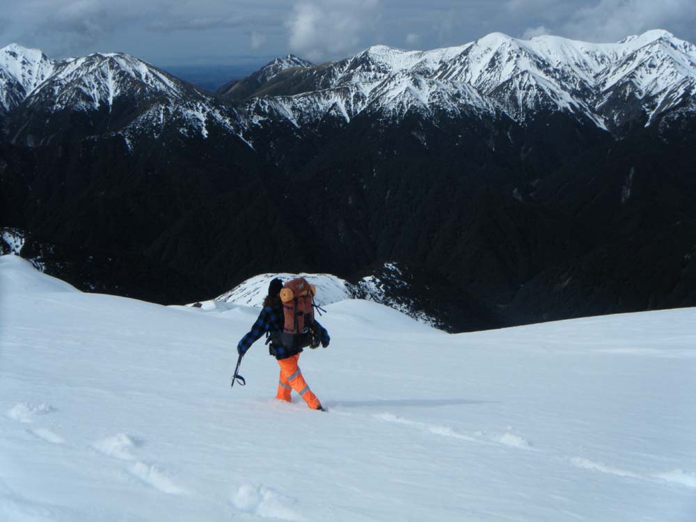
And so began the epic descent. The eternal question: ridge or river? To stay in the safety and serenity of the ridge? Or the excitement and potential danger of the gushing gulley stream? We'd had enough of ridges so we dropped into Trig Creek to find it easy going, apart from several involuntary self-arrests. It was a winter wonderland walk down the snowy stream-side.

En route to the night's riverside camping spot


We later forked onto Iron Peg Creek, and set up camp at the main confluence with the larger Kawhatau River. DOC had told us there may be a shortage of camping spots by the river. Ah, that depends what you're looking for we thought, all we needed was two trees to set up our bivvy! We huddled for warmth by our blazing camp fire, and used the embers to cook bacon, smothered in cream, sautéed onion, capsicum and a feast of pasta.


Fire by the Kawhatau River


Waterfall Hut


By twilight we listened to the unique whistling of the rare Whio - blue duck, while sucking back rich Milo. Eventually we surrended to the cold and shuffled back to the bivouac...

We turned from Waterfall hut into the tight valley that channeled Pinnacle Creek. An easy going stream bash soon became challenging as avalanche paths took hold of our route. Every so often, a false step would shoot through the surface, an alarming reminder of the icy stream gushing beneath our feet. We opted for the safety of the steep tussock and scree coated banks until the avalanche ravaged gulley was our only option. We picked our way up through the upturned chunks of dirty snow into the guts of the climb. At one point we caught sight of a Karearea, a mountain falcon, swooping about the snow tops, surveying his territory.

Climbing the rugged Pinnacle Creek
We took a brief stop near the saddle, and as we taunted the mountain’s summer-like conditions, and before our eyes we witnessed the power of the range. Mist moved in from the north, obscuring the peaks above Waterfall hut. Lets go! The final push to the saddle was almost crampon-worthy but so short that we braved the climb with firm footing into the snow and solid punches of the axe through the icy crust.

We climbed towards a patch of dry rock and tussock slightly higher than the saddle, so when we crested onto the ridge we could see the signs pointing back towards Iron Peg. No way were we heading back just yet - we had unfinished business with the Ruahine.

Weather closing in as we began the traverse
What was to follow would go down on each of our records under "dodgiest thing I've ever done". When scrambling across a narrow rock slab with a loaded pack on all fours seems better than walking around, you know you're in trouble. Luckily the route was easily to follow, we could see the razor-back spine ridge trail away to the right. Unluckily, the ridges were razor-sharp and one slip either side wouldn't be pretty! And so we swallowed hard, and began the trance like procession across each ridge to the rhythm of:

Left foot
Right foot
Ice axe
Breeeathe...

Repeat

Nerve racking ridge traverse...
And so this cycle carried on in almost silence, apart from calls of "You all right back there?" Yeah, fine, never been better!

Lost in mist high on a mountain ridge
This fear-fueled adrenaline march was mentally exhausting, and it was quite difficult to keep the images of falling off the slope away from my mind. Luckily the snow was soft so we could stamp deep footsteps in anchoring ourselves to the slope. When we finally descended to a solid track, we were incredibly relieved! We hadn't stopped for several hours, none of us was overly keen for a lunch break with one leg either side of a ridge top, so by 3pm we were ravenous for lunch. Glad to be in the safety of bush again, we dropped down steeply off the ridge to the Pourangaki river and began constructing camp. Here is the result of three engineers let loose in the bush:

Moments and axial forces balanced
Result: Bivvy of Champions
We chowed down vast quantities of salty Mi-Goreng inside the bivvy while reading Anton Gulley's tramping diary from 2008. Here is an excerpt: "December 27th 2008. Again I just want to point out that even though I did not have a formal tramping trip I was not being lazy this weekend. Taitomo Island is a short climb 5 minutes round the rocks south of Piha and can walked at low tide..." After a soggy night in the bivvy, we threw all our wet gear in our packs and headed towards Pourangaki hut for breakfast. Would you like oats with your oats sir?

Crossing the Pourangaki River
Our final hurdle before the sanctuary of Kelly Knight hut was the Pourangaki tops. With growing fatigue, we pushed towards the bush line for a third time, and with the altitude gain we felt the bitter whip of exposure heading into a hazy whiteout. There was no trail to follow, and slushing through steep, deep snow was a huge effort. Like a cycling peloton we cycled through leaders to share the load.

Through the whiteout...
At the peak we discovered a possum who had courageously climbed as high as he claws could muster, and upon reaching the sign he collapsed into an icy heap. If only he could pass onto his fellow possums the tale of his conquest...

Navigating the tops was tricky in the 20m of visibility we had - Matt Lillis took a compass bearing and we three fanned off in the direction to find the next pole. Eagle-eyed Stefan found his calling in life with a string of remarkable pole sightings, the rest of us squinted into the foggy distance before we could make them out, meanwhile Stefan strode boldy through the deep snow like a man on a mission.

Matt checks the bearing
We managed to avoid walking off any bluffs, and safely made it down the mountain for the final time. The relief slowly sank in that we had overcome all the biggest obstacles so far, and with hardly any mishaps - this was unheard of as far as trips to the Ruahines go, in winter no less.Until that point, Helen was pretty adamant that she was too good for the hut - the rest of us were content to spend the last night in luxury! She quietly conceded just before arriving at Kelly Knight hut - and old hunter's cabin on the outskirts of the forest park named after a famous hunter. Our relief of surviving the ranges almost came too soon, as I foolishly lit the iron fire stove with the bottle of Fuelite still on the bench! Flames licked over the fuming bottle top for a split second before I realised and quickly swiped it away... Phew - major catastrophe averted! We all stood in silence for about ten seconds, quietly internalising a series of complicated situations in our head, ranging from newspaper headlines to projectile motion equations.

Kelly Knight Hut - luckily still standing
I was soon forgiven, and we tapped into a celebratory bottle of Champagne by the roasting fire while eating a pot of ... well... everything. Bliss. The last morning was almost the hardest; our clothes were now thoroughly saturated in mud, sweat, and Ruahines - a toxic substance that. An overgrown trail sidled around the lower reaches of the Pourangaki river before spitting us into farmland. Over the last fence, and we relunctantly farewelled the Ruahines. Five days in the wilderness without seeing another soul, now that's off the beaten track.

I'd recommend a venture in the Ruahines to anyone who wants to experience some raw nature, and a top transalpine journey. For a winter mission you'll need a good amount of back country experience and basic snow skills.

Western Ruahines

And on the seventh day we rested.

And on the eighth day ... 


Further reading: Read about another trip to the same area in even more extreme winter conditions

Trip: Purity, Pourangaki, Kelly Knight (in Winter)


Saturday, 9 July 2011

Bethells 12-hour Rogaine


7pm, 19th February 2010: I set off in a team from Muriwai Beach one late summer evening, taking part in a very unofficial 12 hour Rogaine which would send us through the night searching for make-shift checkpoints hidden along streams, under viewing platforms, around coastal cliffs… I loved it. This exciting and adventurous idea lay as a seed, dormant in the fertile plains of my mind until [ironically] the winter of this year. Noticing that Auckland was lacking any long distance Rogaine events, I decided to take the initiative and launch my own. A challenge for runners, trampers and orienteers alike; the Bethells 12-Hour Rogaine was born.

The event was advertised through tramping clubs, sports forums and word of mouth, with one team even traveling from Hamilton to take part. While the threatening weather forecast saw many last minute pull-outs, we had almost thirty keen participants lining up at the Surf Club gate rearing to go. This extraordinary challenge was set in the unique surroundings of Te Henga, Bethells Beach - a great location for the event; with access to the extensive Cascades track network, Te Henga trail, rugged beaches, sand dunes, and Lake Wainamu. Thirty controls were spread out across the map, with several interesting route choices to consider. Tide times and darkness hours were also thrown into the churning strategy pot, leaving teams some serious thinking to do in the thirty minutes before midnight.

Walkers would become trampers, trampers would become navigators, and navigators would become endurance athletes, as they were thrown into the dark, and the ugly, for a full twelve hours of glorious adventure. As Charles Dickens famously said, “The men who learn endurance, are they who call the whole world, brother”.

Held in the guts of winter, the wild West Coast lived up to its name. Teams who chose to start along the Te Henga Walkway, a dramatic 9 kilometre section of coastal track, were belted with sou’westerlies in the silhouette-shadow landscape of the early morning. Andrew Turnbull from team “The Camel & the Straw” said, “It was a really awesome event, the Te Henga trail in the wind and the rain was epic.”

At each checkpoint, a short clue narrowed down the likely whereabouts of the treasure, in the form of red & white plastic tape. Each location had a unique two-letter code that teams would write down to prove their conquest. Each code was an acronym describing something about the surroundings, e.g. a tape-wrapped rock hidden in a crevasse around the coast of Erangi point that was only accessible at low tide had the code ‘LT’. The further out they ventured from the base, the more points they could earn. If teams managed to trek out as far as Ongaruanuku Hut, they would be stoked to find some red & white tape hanging in the woodshed. One team decided to treat themselves to a power nap at the hut before the homeward journey, via a waterfall traverse at Pig Wallow, some tree climbing on Chateau-Mosquito, a stream bash down the Wainamu, and finishing with a rock climb and some cave exploring on Bethells Beach, before collapsing at the finish. Elated, and alive.

Substantial calories were replaced at the finish with hearty servings of pumpkin soup, warmed to perfection with the trusty club primus. Matt Lillis, notable gourmet outdoor chef de cuisine found the generously frosted chocolate cake to be “succulent and moist”.

Helen Liley and myself spent two days tramping through the Waitakeres setting up the course the week prior, finding interesting locations and writing clues on the go. We slept at O’nuku Hut and in a spectacular bivvy against the cliffs of Bethells Beach the following night. Luckily it wasn’t tested for water-proofness.

The Bethells 12-Hour Rogaine was a huge success in its first running; all the teams seemed to arrive back at base looking shattered, but exhilarated by the experience of going hard all through the night, and walking into the new day. 


The overall winner was elite women’s adventure racing team, Team Macpac Girls on Top, who managed to cover a 53km loop (with an impressive 2187m vertical gain) around all three sections of bush, picking up all but two checkpoints!
Following this success, we plan to organise more of these longer Rogaines in the future, and also hope that this will inspire others to organise similar events. We have our sights set on running a Hunua 12-Hour Rogaine for November 2011, and a Karekare 12-Hour Rogaine for February 2012. Planning will start soon, so watch this space for more details to come!


Final Results (Maximum score 1840)
1.  Macpac Girls On Top – 1600
a.  Anne Lowerson, Debbie Chambers, Cath Heppelthwaite
2.  Dash Hounds – 1150
a.  Mike Judd, Rupert Dash, Steve Pyatt
3. : Hamilton Devilled Eggs – 930
a.  Elliot O’Brien, Isaac Dempsey, Nick Vignati, Craig Smith
4.  Team Type 1 – 820
a.  Claire Dobson, Alan Dobson
5.  Tim & Tony – 760
a.  Timothy Burrell, Tony Hastie
6.  Cool Katz – 550
a.  Hannah Lockie, Tane Moore, Matt Martin
7.  Matt’s Crew – 380
a.  Matt Lillis, Laurien Heijs, Georgia Yarrow, Rosanna Walton
8.  Peter & David – Disq
a.  Peter Guillburt, David Keall
9.  Camel & the Straw – Disq
a.  Andrew Turnbull, Hannah Lowe
10.  Otago University Tramping Club – Disq
a.  Edward Colenbrander, James West, Ian Grimson, Malcolm Durling


Sunday, 24 April 2011

Round the Mountain Ruapehu


The Round the Mountain track circumnavigates Mount Ruapehu, one of the most predominant volcanic cones in the North Island. Its a stunning journey through sub-alpine terrain and now one of my favourite tracks in New Zealand.


Ruapehu's shining peaks of Paretetaitonga, Tahurangi and Girdlestone


NEARBY TOWN/CITY: Whakapapa Village, Tongariro National Park
EXACT LOCATION: Walk up Bruce Rd, past DOC info centre, past Shelter. Whakapapaiti track begins down lane to the right off Bruce Rd.
TOTAL ROUTE DISTANCE: 70km
TOTAL ASCENT & DESCENT: Around 2,000m
TIME TO COMPLETE: Elite-12hrs; Weekend Warrior -16hrs+; Non-stop tramping–20 hours
TYPE OF TRAIL RUN: Loop. Best run anti-clockwise, starting/ending at Whakapapa Village. This way you tackle the tough “Goat” section first on fresh legs, and finish on the easy, board-walked “Tussock Traverse” section over Tama Saddle.
DIFFICULTY: Very Hard.
DEFINING CHARACTERISTICS: Sub-Alpine, technical, remote
START GPS: Latitude -39.20316060 S, Longitude 175.53980827 E
FINISH GPS: Same as start
BEST MAP/S: NZ Topo50 BH34, BH35, BJ34, BJ35 (Mostly on BJ34)


Early start at Whakapapa Village

RUN IT: The best time to run the Ruapehu circuit is between October – May, as this is an all-day affair you’ll want to maximize daylight hours, and being a remote alpine environment, bad weather can also make this run dangerous. Plenty of food, thermals and a wind/rain-proof jacket are essential. Water is not so much an issue, you can fill up at each hut (spaced roughly 2-3 hrs run apart), and also in the clean streams and rivers. Ruapehu’s eastern side is particularly remote. Once you pass Ohakune Mountain Rd and venture into the desert, you are miles away from civilization. In good conditions however, this all adds to the experience!

Boardwalk by Mangaturuturu
Begin your run before dawn and head along the Whakapapaiti track, through lush Beech forest and crossing several bridged stream crossings until you reach the Whakapapaiti Stream. You will cross to the west side, where you make your way through muddy tussock lands, re-cross at the forked section of the stream shortly before reaching the hut. About 2 hours in, you should wake up the trampers and invite yourself in for some morning coffee fresh off the primus.

The Waterfall face
Southern Ruapehu - Mangaehuehu
Continue on the trail and you’ll soon intersect the Round the Mountain circuit track, and begin “The Goat” section – steep, gnarly gullies will work you up and down, but with any luck, stunning views of Paretetaitonga will inspire you onwards. The trail swings you down a spur where you pass the pristine Lake Surprise, descend a steep gulley to Mangaturuturu hut. Follow the boardwalk to the river, cross, and the trail continues to the left, towards the Cascades waterfall. This steep waterfall face is a tough and long climb which may have even reduced Sjors Corporaal to a power-walk.

Dropping into the great gulley
Endorphin-fuelled fun across the Waihianoa Glacier

Jog down Ohakune Mountain Rd for 3km, and reconnect the track at car park to your left. The section to Mangaehuehu hut is a well groomed trail, and features a 39m waterfall – Ruapehu’s highest. Soon after, you negotiate a 3-wire bridge crossing, and some interesting sub-alpine running through alpine herb fields. Refill your bladder here before heading into the wilderness that is the Rangipo desert. The trail turns into a poled route shortly after leaving the hut, so a compass would be useful in low visibility conditions. The Waihianoa glacial valley is spectacular; stop for a moment to take it in. Then blitz the descent and carry your momentum up the following, grueling, ascent. Apart from this workout, climbing is moderate. Dig it in - follow the undulating traverse across barren desert towards Rangipo hut.

Rangipo Desert - 20km to go
Crampons not necessary when you have Inov-8 BareGrip 200s!
Once you reach the Tukino Ski field road you are on the home-straight, only 27km of fast running remains. The landscape is vast and exposed - the never-ending rocky horizon and your growing fatigue will make progress seem futile. Now is a good time for some energy gels to raise your sugar levels and morale. Resist the temptation of a hot meal at Waihohonu Hut; you will never be able to leave! Instead cut the corner to the west and clip onto the Tama lakes track and begin the (barely noticeable) ascent to Tama Saddle. Switch on the headlamps, and finish strong along the easy board-walked track. Listen out for the gushing Taranaki falls, and flickering lights of the Chateau…

You’ve done it, a complete circumnavigation of the North Island’s most predominant mountain. “One does not simply walk into Mordor… one simply runs!”

Ruby running in the rain

POST RUN GOODNESS: The Tussock Bar. Drive 50m past Chateau, on the left. This bar/restaurant is an absolute jewel after this epic mission. I highly recommend ordering a plate of Volcanic Wedges, with extra bacon & cheese. Victory is yours!


Self transcendence at the end of the 13-hour journey
A complete circumnavigation of Ruapehu's vast flanks is a great achievement